Anderson Valley Graveyards

E.M. Hiatt, who retired as Yorkville Postmaster in 1889, shown here with his wife, Elizabeth
We have four cemeteries in the Anderson Valley that are administered by the Anderson Valley Cemetery District. We’ve included instructions to find the cemeteries and some basic information below, as well as a widget from the findagrave.com website which allows you to search for buried persons by surname. Most of the markers have been photographed and are available on the Find-A-Grave site. For more information about a particular person contact the administrator of that person’s internment entry on the findagrave.com website.
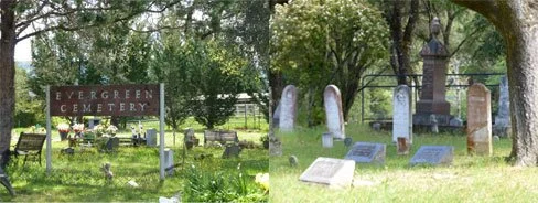
Evergreen Cemetery, Boonville, California
Photos by Mary Darling
GPS Coordinates: Latitude: 39.02518, Longitude: 123.38168
This is the largest cemetery in the Anderson Valley. It is located on the West end of Boonville off Anderson Valley Way. Anderson Valley Way (the old highway) parallels Hwy 128. You can turn onto Anderson Valley Way at two points and the cemetery entrance is between. Some of the oldest markers are next to Anderson Valley Way; however, vehicle access and parking is just west of this area. The oldest tombstone dates to 1862. Pre-1900 tombstones give evidence of many pioneer families. Well-represented families are: Ball, Brown, Clow, Ingram, McAbee, McGimsey, Ornbaun, Prather, Rawles, and Witherell. Descendents are Valley residents to this day. Susan Stubblefield, a very important early pioneer woman who “doctored” in the Valley from the 1860’s is here. She brought the “Grandma Stubblefield” rose westward and the rose can still be seen in the Valley.
Rawles-Babcock Cemetery, Boonville, California

Photos by Mary Darling
GPS Coordinates: Latitude: 39.003298, Longitude: 123.230805
This cemetery is a little difficult to find. Take Mountain View Road going west from the west end of Boonville. After the south end of the airport runway and just before the highway curves to the right, take the driveway on the left that goes straight up a hill. After you crest the hill the parking area for the cemetery will be on the left with plenty of parking. The cemetery is on a knoll looking out over the Boonville Airport, the AV High School and Mountain View Road – one of the truly loveliest spots in the Valley.
In 1978, Mrs. Alva Ingram recorded the markers in the cemetery and noted “there are many graves outside the fence with small wooden markers without names. Also in the fenced cemetery are wooden markers without dates or names.” Early families well represented here are Babcock, Burger, Tarwater, McGimsey, Lowrey, Rawles and Beeson. The earliest era of markers is from the first decades of the 1900’s. The oldest existing marker is that of Henry Beeson, who, when he died in 1914, had been the oldest member of the Bear Flag Party and participated in the Bear Flag Revolt at Sonoma, CA in 1846.
Shields-Studebaker Cemetery, Philo, California

Photos by Mary Darling
GPS Coordinates: Latitude: 39.08780, Longitude: -123.46940
Traveling west on Highway 128 from Philo to the coast, you will pass the Gowans’ Fruit Stand on the left after about 4 miles. The highway then bends to the right and just as it bends again to the left and at highway marker 20.5, take the dirt driveway on the right. After passing a couple of residences you come to a “Y”. Take the right and you will soon see the cemetery sign. There is a gate (always unlocked) to open and close before you reach the cemetery. There is plenty of parking and a magnificent view over the valley looking towards Philo. As in all the cemeteries there are a multitude of wildflowers in bloom in April and May. There is a large planting of Watsonia (a gladiola-like bulb) which blooms in May.
This cemetery is close to the old community of Christine (not currently a town). Many of the pioneers here were Swiss and the town was named for the first Pioneer child born in the area: Christine Gschwend Reilly. The oldest markers are dated from the 1880’s. Larger groups of family names here are Guntly, Whipple, Frati, Eten, Nunn, Salmella, Studebaker, Gschwend, Price, Day, Reilly, Bloyd, and Gossman.
Yorkville Cemetery, Yorkville, California

Photos by Valerie Hanelt
GPS Coordinates: Latitude: 38.544844 Longitude: 123.162937
Hwy 128 Milepost Marker: 37.82
This cemetery is located directly off Highway 128. Parking is available at the bottom of the driveway, although there is room for one car in front of the gate if easier access is needed. The early Yorkville pioneer families are here: Adams, Elkins, Ledford, Lowrey, McAbee, Nobles, Stubblefield and York, amongst others. Robert Stubblefied has the oldest marker; he died in 1877 at the age of 70. Also there are reported to be some Native Americans of the Yorkville area Ma-cum-muk Pomo tribe: Chief Commancha and his son Mol-ik-y as well as Small Bone and his son Dick Small Bone. The notes of Effie McAbee Hulbert (unfortunately undated but before her death in 1969) recall many of those in unmarked graves.
Ingram Cemetery, Yorkville, California
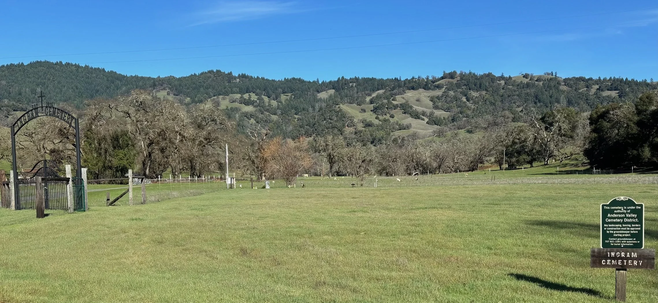
Photo by Sheri Hansen
The Anderson Valley Cemetery District was running short of space in their cemeteries and looking for additional property. The Ingram family was seeking a way family members could be interned on their beloved ranch. In 2022, the District purchased two acres of the Ingram ranch and established a new Anderson Valley cemetery. Marie Hill, whose grandparents, Irvin and Ruth Ingram purchased the ranch in 1911, signed the final documents just over a week before she passed. Jim Hill, who still resides on the Ingram Ranch moved his great grandparents, Irvin and Ruth Ingram, his grandparents, his father and sister to the newly established Ingram Cemetery.
The cemetery sits in a beautiful valley and adjacent to Ingram creek. It is easily accessible from Highway 128, east of Yorkville.
E.M. Hiatt, who retired as Yorkville Postmaster in 1889, shown here with his wife, Elizabeth
We have four cemeteries in the Anderson Valley that are administered by the Anderson Valley Cemetery District. We’ve included instructions to find the cemeteries and some basic information below, as well as a widget from the findagrave.com website which allows you to search for buried persons by surname. Most of the markers have been photographed and are available on the Find-A-Grave site. For more information about a particular person contact the administrator of that person’s internment entry on the findagrave.com website.
Evergreen Cemetery, Boonville, California
Photos by Mary Darling
GPS Coordinates: Latitude: 39.02518, Longitude: 123.38168
This is the largest cemetery in the Anderson Valley. It is located on the West end of Boonville off Anderson Valley Way. Anderson Valley Way (the old highway) parallels Hwy 128. You can turn onto Anderson Valley Way at two points and the cemetery entrance is between. Some of the oldest markers are next to Anderson Valley Way; however, vehicle access and parking is just west of this area. The oldest tombstone dates to 1862. Pre-1900 tombstones give evidence of many pioneer families. Well-represented families are: Ball, Brown, Clow, Ingram, McAbee, McGimsey, Ornbaun, Prather, Rawles, and Witherell. Descendents are Valley residents to this day. Susan Stubblefield, a very important early pioneer woman who “doctored” in the Valley from the 1860’s is here. She brought the “Grandma Stubblefield” rose westward and the rose can still be seen in the Valley.
Rawles-Babcock Cemetery, Boonville, California
Photos by Mary Darling
GPS Coordinates: Latitude: 39.003298, Longitude: 123.230805
This cemetery is a little difficult to find. Take Mountain View Road going west from the west end of Boonville. After the south end of the airport runway and just before the highway curves to the right, take the driveway on the left that goes straight up a hill. After you crest the hill the parking area for the cemetery will be on the left with plenty of parking. The cemetery is on a knoll looking out over the Boonville Airport, the AV High School and Mountain View Road – one of the truly loveliest spots in the Valley.
In 1978, Mrs. Alva Ingram recorded the markers in the cemetery and noted “there are many graves outside the fence with small wooden markers without names. Also in the fenced cemetery are wooden markers without dates or names.” Early families well represented here are Babcock, Burger, Tarwater, McGimsey, Lowrey, Rawles and Beeson. The earliest era of markers is from the first decades of the 1900’s. The oldest existing marker is that of Henry Beeson, who, when he died in 1914, had been the oldest member of the Bear Flag Party and participated in the Bear Flag Revolt at Sonoma, CA in 1846.
Shields-Studebaker Cemetery, Philo, California
Photos by Mary Darling
GPS Coordinates: Latitude: 39.08780, Longitude: -123.46940
Traveling west on Highway 128 from Philo to the coast, you will pass the Gowans’ Fruit Stand on the left after about 4 miles. The highway then bends to the right and just as it bends again to the left and at highway marker 20.5, take the dirt driveway on the right. After passing a couple of residences you come to a “Y”. Take the right and you will soon see the cemetery sign. There is a gate (always unlocked) to open and close before you reach the cemetery. There is plenty of parking and a magnificent view over the valley looking towards Philo. As in all the cemeteries there are a multitude of wildflowers in bloom in April and May. There is a large planting of Watsonia (a gladiola-like bulb) which blooms in May.
This cemetery is close to the old community of Christine (not currently a town). Many of the pioneers here were Swiss and the town was named for the first Pioneer child born in the area: Christine Gschwend Reilly. The oldest markers are dated from the 1880’s. Larger groups of family names here are Guntly, Whipple, Frati, Eten, Nunn, Salmella, Studebaker, Gschwend, Price, Day, Reilly, Bloyd, and Gossman.
Yorkville Cemetery, Yorkville, California
Photos by Valerie Hanelt
GPS Coordinates: Latitude: 38.544844 Longitude: 123.162937
Hwy 128 Milepost Marker: 37.82
This cemetery is located directly off Highway 128. Parking is available at the bottom of the driveway, although there is room for one car in front of the gate if easier access is needed. The early Yorkville pioneer families are here: Adams, Elkins, Ledford, Lowrey, McAbee, Nobles, Stubblefield and York, amongst others. Robert Stubblefied has the oldest marker; he died in 1877 at the age of 70. Also there are reported to be some Native Americans of the Yorkville area Ma-cum-muk Pomo tribe: Chief Commancha and his son Mol-ik-y as well as Small Bone and his son Dick Small Bone. The notes of Effie McAbee Hulbert (unfortunately undated but before her death in 1969) recall many of those in unmarked graves.
Ingram Cemetery, Yorkville, California
Photos by Sheri Hansen
The Anderson Valley Cemetery District was running short of space in their cemeteries and looking for additional property. The Ingram family was seeking a way family members could be interned on their beloved ranch. In 2022, the District purchased two acres of the Ingram ranch and established a new Anderson Valley cemetery. Marie Hill, whose grandparents, Irvin and Ruth Ingram purchased the ranch in 1911, signed the final documents just over a week before she passed. Jim Hill, who still resides on the Ingram Ranch moved his great grandparents, Irvin and Ruth Ingram, his grandparents, his father and sister to the newly established Ingram Cemetery.
The cemetery sits in a beautiful valley and adjacent to Ingram creek. It is easily accessible from Highway 128, east of Yorkville.